Settle, the waterfall of Scaleber Force, geological wonders and prehistoric Jubilee Cave.

Table of Contents
The Route
- what3words for start point: ///comply.solving.sublet
- Start / Finish Point: Market Pl, Settle BD24 9EJ
- Distance: 6.5 Miles
GPX Route Map
Download file for GPSWalk Description
From the lovely old market town of Settle in Ribblesdale, this walk heads to the dramatic waterfall of Scaleber Force, set in a wooded ravine.
Here the waters of Scaleber Beck cascade down over limestone ledges formed by the South Craven Fault. The Craven Fault Lines define the southern geological boundary of the Yorkshire Dales, where the underlying rocks were displaced many hundreds or metres during the Carboniferous period over 300 million years ago.
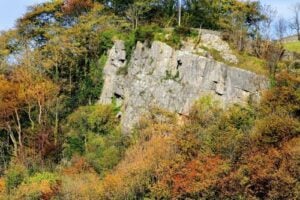
From Scaleber Force, our walk heads northwards to soon reach Warrendale Knotts, a dramatic cliff of shattered limestone crags and hills along the Mid Craven Fault, which is also responsible for Malham Cove and Gordale Scar.

As you approach Warrendale Knotts you pass Sugar Loaf Hill, which is a Reef Knoll that was formed along the edge of these fault lines as coral reefs in a shallow tropical sea when this whole area was near the equator.

A rocky path now heads northwards, with a detour up to the right to reach the incredible Victoria Cave.

Deposits within this cave chart the climate and human history of the Yorkshire Dales, as animal bones from hippos, short-nosed rhino, elephants and hyenas have been discovered in thick glacial clay deposits. These animals lived in this area 130,000 years ago during a warm interglacial period. Above these deposits, a 11,000 year old harpoon tip made from reindeer bone was discovered dating back 11,000 years ago from when the first human hunter-gatherers arrived after the end of the last ice age during the Palaeolithic period. Similar discoveries have been found in nearby Jubilee Cave.