Starting and finishing at Selby Abbey, Selby Horseshoe heads along the Selby Canal towpath, on well-trodden paths and through Brayton Barff’s ancient woodland, taking in a whole myriad of wildlife.

Table of Contents
The Route
- Start / Finish Point: Selby Abbey, The Crescent, Selby YO8 4PU
- Distance: 9 Miles
GPX Route Map
Download file for GPSWalk Description
This nine mile circular route, with sections along Selby Canal towpath, past Selby Dam, through spectacular ancient oak woodland in Brayton Barff, and along well-trodden tracks and footpaths, is a pleasant stroll for all seasons. It’s particularly good in spring when a variety of wildflowers and birds can be seen. If you are lucky, this walk should offer you the chance to spot a whole myriad of wildlife, especially water birds along the canal side.
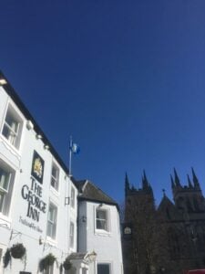
As the route starts and finishes at Selby Abbey, it’s the perfect opportunity for you to visit. Overflowing with heritage and culture, the great Norman Selby Abbey, founded under William the Conqueror by Royal Charter, is the jewel in Selby District’s crown. The Norman Nave and “Decorated” Chancel are considered to be among the finest examples of 12th and 14th Century architecture in England. The Abbey is reputed to be the birthplace of King Henry I of England, the son of William the Conqueror and also links to the modern-day American flag, with its Washington Window. With an international reputation as one of the most important church buildings in the world, and with many fascinating human stories linked to its 1000 year history, Selby Abbey is a delight to visit
Once you’ve had chance to marvel at the magnificent Selby Abbey, follow the route, as follows:
- Starting from Selby Abbey head in a south easterly direction along the A1041 Bawtry Road pavement.
- Join the canal towpath on the north side of the road bridge, near the traffic island from which Canal Road leads off to the left. Pass under the bridge and follow the towpath south westerly for about 3 miles.
- Turn right (away from the canal) at Burton Bridge and follow the bridleway towards Selby Golf Club.
- Cross the road, go through the kissing gate and follow the public footpath off to the right, through a gorse shrubbery, turning left to follow the golf course perimeter path. Continue over the A63 (Selby Bypass) where the path heads through Brayton Barff woodland.
- Emerge from the woods and cross over Barff Lane to join the bridleway up to the busy A1238 and Thorpe Willoughby. Carefully cross over the road and turn left along the pavement/footway.
- Turn right onto a minor road – Dam Lane – and follow this road for approximately 400 metres, then turn right onto a public footpath at the signpost just beyond Thorpe Hall.
- Follow the farm track/path, keeping the hedge to your left, and eventually the route passes Cross Hills Farm and becomes a hard surfaced track.
- Soon after reaching the edge of town, at the road junction by the playground, turn right onto Flaxley Road.
- Continue along the pavement, then turn right into Scott Road, then left at the traffic lights to the Gowthorpe main shopping area. This leads back to the start of the walk at Selby Abbey.