
Ordnance Survey Ireland Map of Cork: OSI Street Map
by Ordnance Survey Ireland
£10.99
GTIN09781908852748
EAN9781908852748
MPN6698
Prices updated 7 Jun 2026
Compare 1 Retailer
Prices checked 9d ago
Ordnance Survey
BEST PRICEIn stockStandard
£10.99
Best PriceAmazon
Check live price on Amazon.co.uk
eBay
Check availability and price on eBay.co.uk. Yorkshire.com may be paid for purchases made through this link, by eBay Partner Network.
Can’t find it elsewhere?
Product Description
Explore Cork confidently with this detailed and dependable street map. Travel easily using clear mapping across the city and suburbs. Discover roads, districts, and central areas with precise OSI clarity. Explore the city centre using enlarged map inserts. Navigate pedestrian streets and historic quarters confidently. Follow major access routes and key transport corridors easily. Plan journeys using the alphabetical street index provided. Find hospitals, churches, and public‑interest locations quickly. Enjoy simple city navigation supported by accurate OSI mapping. Experience Cork with a reliable OSI street map. Why an OSI Street Map? Enjoy clear street mapping for reliable city navigation. Use enlarged city‑centre extracts for detailed exploration. Follow precise OSI markings with confidence. Find key sites using the full street index. Navigate main roads using labelled routes. Identify public buildings with clear OSI symbols. This map is perfect for walking and city travel. Explore historic areas easily on foot. Keep one to hand for everyday Galway navigation. Specifications: Publication Date: 05/09/2016 Map Scale: 1:20 000 Map Format: Folded
More products from Ordnance Survey
Browse their full range on Yorkshire.com
Popular in Construction
Browse all Construction
Everbuild Jetcem Deep Rapid Repair Sand and Cement 6Kg
£33.90
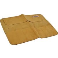
Faithfull 8 Pocket Leather Chisel and Small Tool Roll
£25.90
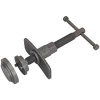
Sealey VS0240 4 Piece Brake Piston Wind Back Tool Kit
£34.90
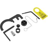
Sealey VSE6121A Diesel Engine Timing Tool Kit for BMW, BMW Mini 1.5D, 1.6D, 2.0D, 3.0D
£109.90

Siegen 10 Piece T Handle Torx Key Set
£25.90

Sealey RT014 3 Piece Mini Trim Panel Removal Set
£17.90
Deals from Construction retailers
From£10.99Ordnance Survey
Buy Now