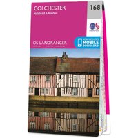
Ordnance Survey OS Map of Colchester: Landranger 168
by Ordnance Survey
£7.80from 3 retailers
GTIN09780319262665
EAN9780319262665
MPN6208
Prices updated 21 Jun 2026
Compare 3 Retailers
Save up to £5.19 by comparingPrices checked 6h ago
In stock£3.99 delivery3 to 5 daysNew
In stock£4.99 delivery3 to 5 days
In stockStandard
Amazon
Check live price on Amazon.co.uk
eBay
Check availability and price on eBay.co.uk. Yorkshire.com may be paid for purchases made through this link, by eBay Partner Network.
Can’t find it elsewhere?
Product Description
Colchester (inc. Halstead & Maldon) map - OS Landranger 168 Format: Folded map Physical Size: 1000 x 890 mm (134 x 227 mm folded) Standard Publication Date: 24/02/2016 Weatherproof Publication Date: 24/02/2016
More products from Millets
Browse their full range on Yorkshire.com
Popular in Marine Chart Plotters & GPS
Browse all Marine Chart Plotters & GPS
Admiralty A Class Chart - 1954 Cape Wrath to Pentland Firth
£57.18
Admiralty Chart 2379 Loch Linnhe Central Part
£50.85

Admiralty Chart 1757 The Little Minch - Northern Part
£50.85

Admiralty Chart 1119 Orkney and Shetland Islands Fair Isle Channel
£50.84

Admiralty Chart 2210 Approaches to Inner Sound
£50.85

Admiralty Chart 3281 Shetland Islands North-West Sheet
£50.84
Deals from Marine Chart Plotters & GPS retailers
From£7.80Millets
Buy Now