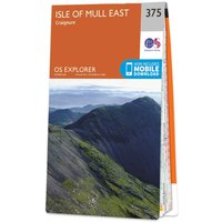
Ordnance Survey OS Map of Isle of Mull East: Explorer 375
by Ordnance Survey
Compare 1 Retailer
Ordnance Survey
BEST PRICEAmazon
Check live price on Amazon.co.uk
eBay
Check availability and price on eBay.co.uk. Yorkshire.com may be paid for purchases made through this link, by eBay Partner Network.
Can’t find it elsewhere?
Product Description
More products from Ordnance Survey
Browse their full range on Yorkshire.com
Popular in Marine Chart Plotters & GPS
Browse all Marine Chart Plotters & GPS
Admiralty Chart 1906 Kyles of Bute
£50.85

Admiralty Chart 2528 Loch Gairloch and Loch Kishorn to Strome Narrows
£50.85
Admiralty Chart 2724 North Channel to the Firth of Lorne
£50.84

Imray Outer Hebrides - Clyde Cruising Club
£48.95

Admiralty Chart 1077 Approaches to Cromarty Firth and Inverness Firth
£55.25

Admiralty Chart 2394 Loch Sunart
£50.84
What You're Buying
What Yorkshire.com visitors have been buying recently

Ortigia - Fico d'India Body Cream 300 ml - Moisturizing Body Cream
£61.00

ASUS ROG Strix OLED XG27ACDMS 27-Inch Gaming Monitor
£573.07

Oman Luxury - Wasla Eau de Parfum 100 ml - Unisex Woody Perfume
£220.00

Hyundai 56cc Petrol Brushcutter and Grass Trimmer, 2-in-1, Includes Harness
£119.99

Continental VanContact Ultra ( 215/65 R16C 109/107T 8PR Dual Branding 106T, EVc )
£135.25

Bluebella Latex Suspender Black - XS
£64.00